文章目录
- 一、经度、纬度概念
- 二、根据经纬度计算距离
一、经度、纬度概念
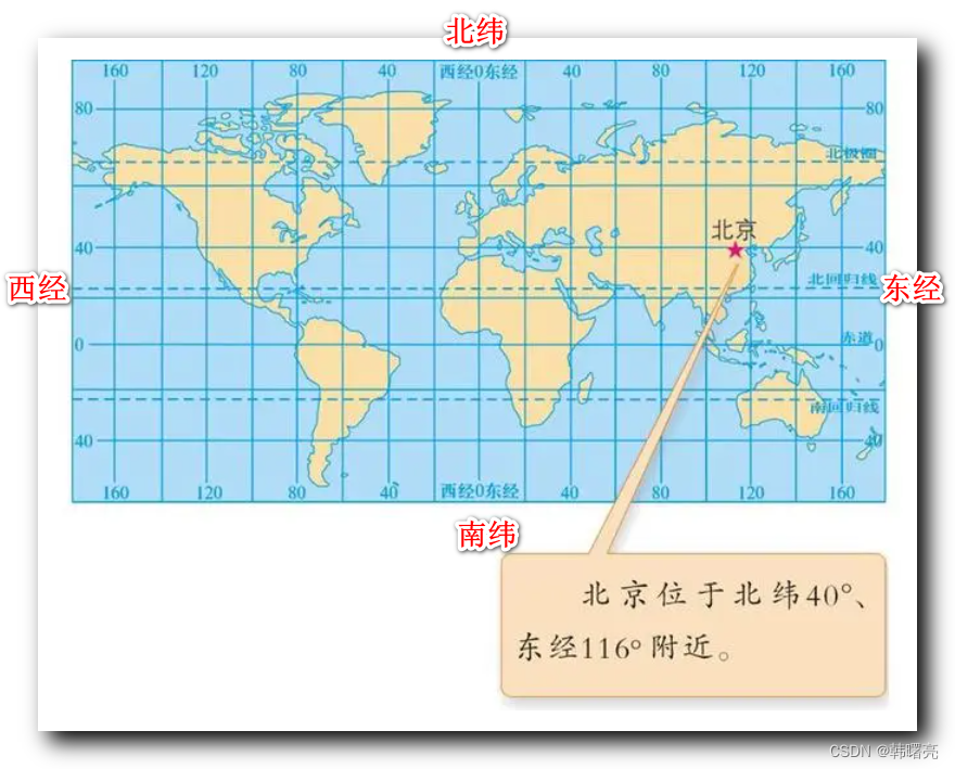
经度 Longitude , 本初子午线 位置 为 0 度经线 , 相当于水平 x 轴 的坐标 , 经度的取值范围 -180 度 ~ +180 度 ;
纬度 Latitude , 相当于 垂直 y 轴 的坐标 , 纬度的取值范围 -90 度 ~ + 90 度 ;

在这里插入图片描述
西经 和 南纬 是负数 ;

在这里插入图片描述
二、根据经纬度计算距离
根据 球面三角学 和 Haversine 公式 , 计算 两个 经纬度 之间的距离 :
- Java 语言 :
代码语言:javascript
复制
public class LocationUtils {private static final double EARTH_RADIUS = 6371; // 地球平均半径,单位为公里 public static double getDistance(double lat1, double lon1, double lat2, double lon2) { double radLat1 = Math.toRadians(lat1); double radLat2 = Math.toRadians(lat2); double a = radLat1 - radLat2; double b = Math.toRadians(lon1) - Math.toRadians(lon2); double s = 2 * Math.asin(Math.sqrt(Math.pow(Math.sin(a / 2), 2) + Math.cos(radLat1) * Math.cos(radLat2) * Math.pow(Math.sin(b / 2), 2))); s = s * EARTH_RADIUS; s = Math.round(s * 1000) / 1000.0; // 保留三位小数 return s; }
}
- Python 语言 :
代码语言:javascript
复制
import math
def distance(lat1, lon1, lat2, lon2):

R = 6371 # 地球半径,单位为公里

dlat = math.radians(lat2 - lat1)

dlon = math.radians(lon2 - lon1)

a = math.sin(dlat/2) * math.sin(dlat/2) + math.cos(math.radians(lat1))

* math.cos(math.radians(lat2)) * math.sin(dlon/2) * math.sin(dlon/2)

c = 2 * math.atan2(math.sqrt(a), math.sqrt(1-a))

d = R * c # 距离,单位为公里

return d